


Before you leave...
Take 20% off your first order
20% off
Enter the code below at checkout to get 20% off your first order
Discover summer reading lists for all ages & interests!
Find Your Next Read
- Waterproof - Tear-Resistant - Topographic Map
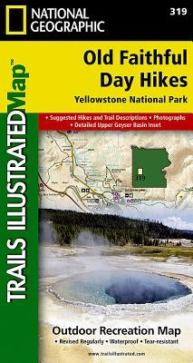
National Geographic's Trails Illustrated map of the Old Faithful area of Yellowstone National Park is designed to meet the needs of visitors with unmatched detail of the upper and midway geyser sections of the national park. Expertly researched and created in partnership with local land management agencies, this map features key points of interest including the Old Faithful geyser area, Midway Geyser Basin, Old Faithful, and Fountain Paint Pots. A list of recommend day hikes includes distances and difficulties. The Continental Divide Trail passes through this map.
With many miles of mapped trails and marked Bear Management Zones the Old Faithful Day Hikes map can guide you off the beaten path and back again. The clearly marked trails include mileages between intersections. The map base includes contour lines and elevations for summits, passes and many lakes. Some of the many recreation features include: visitor centers, campgrounds, trailheads, hydrothermal features and interpretive trails.
Every Trails Illustrated map is printed on "Backcountry Tough" waterproof, tear-resistant paper. A full UTM grid is printed on the map to aid with GPS navigation.
Other features found on this map include: Yellowstone National Park.
Not available to be shipped via Media Mail
Thanks for subscribing!
This email has been registered!
Take 20% off your first order
Enter the code below at checkout to get 20% off your first order