


Before you leave...
Take 20% off your first order
20% off
Enter the code below at checkout to get 20% off your first order
Discover summer reading lists for all ages & interests!
Find Your Next Read
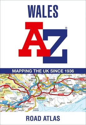
Full-colour road atlas of Wales, with extended coverage into England and including all the major routes into the country. The detailed road mapping also includes Liverpool, Warrington, Nantwich, Shrewsbury, Hereford, Bristol and Severn River Crossings.
Published at a clear 2.5 miles to 1 inch the following features are shown on the road mapping:
Motorways open with full junction detail, motorways under construction and proposed, motorway service areas, primary routes and destinations, A and B roads, selected minor roads, gradients 1:5 and steeper, tolls, mileages, national and county boundaries, spot heights and hill shading Selected places of interest, tourist information centres and golf courses National Park boundaries for Snowdonia, Brecon Beacons and Pembrokeshire CoastAlso included are 21 city, town, airport, or port plans for; Aberystwyth; Bangor; Cardiff; Caernarfon; Carmarthen; Chester; Colwyn Bay; Hereford; Llandudno; Llanelli; Merthyr Tydfil; Newport; Prestatyn; Rhyl Shrewsbury; Swansea; Wrexham; Cardiff International Airport; Holyhead Port; and Pembroke Dock.
Two separate indexes provide extensive coverage of cities, towns, hamlets, and places of interest within Wales. Corresponding map symbols alongside each entry make for easy identification.
Author: Geographers' A-Z Map Co Ltd
ISBN-10: 0008560552
ISBN-13: 9780008560553
Publisher: Geographers' A-Z Map Company Ltd.
Language: English
Published: 04/13/2023
Pages: 92
Format: Folded
Weight: 0.30lbs
Size: 10.00h x 7.00w x 0.20d
Not available to be shipped via Media Mail
Thanks for subscribing!
This email has been registered!
Take 20% off your first order
Enter the code below at checkout to get 20% off your first order